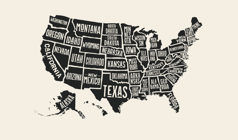
There are technically 50 states in the USA, but let’s face it: some of them are cheating. Take Alaska, for example – clearly a part of Canada, sorry guys, but look at a map – or Hawaii, which is separated from the rest of the states by about 3,860 kilometers (2,400 miles) of ocean and therefore by all rights should be its own country.
And then there are the double states – your Dakotas, Virginias, and Carolinas. For some reason, these three states decided at some point to split themselves into North and South, or West and… well, not-West.
And while 50 is undoubtedly a nice round number, splitting three states into six seems like more effort than that reward deserves. So why did they do it?
Why two Dakotas?
Dakota Territory – singular – was first established as part of the United States in 1861, and it was, compared to the states’ areas today, huge. That’s not just because it was the size of both modern Dakotas combined – it also contained within its borders almost all of Montana and Wyoming, too. In fact, more than half of what was Dakota Territory is now one of those two states.
After a bit of quite dramatic border shuffling with neighboring Idaho Territory, and the loss of Wyoming Territory in 1868, The Dakotas were reduced to basically what they are today – but it would take three more years before they officially split into two. So, what was the cause of the divorce?
Like so much of US expansionism through the ages, the root cause of the split was a brutal combination of colonialism and capitalism. To put that in context: before the mid-1860s, interactions between the Native peoples of Dakota Territory – the name “Dakota” comes from the Dakota Sioux tribe who were indigenous to the area, but many other tribes lived there too – and the relatively few white traders, explorers, and military personnel who visited the region were… mostly peaceful. But that all changed in 1874, for one simple reason: gold.
“The Treaty of Fort Laramie granted the Sioux nation ownership of the Black Hills, which were considered sacred grounds for the Sioux (also known as the Lakota) and Cheyenne Indians,” explains PBS’s American Experience. “There the Native Americans would live on the newly-created Great Sioux Reservation.”
But in 1874, the US government sent out a military excursion led by General Custer – yes, that General Custer – to investigate the potential natural resources in the area. Unfortunately for the Sioux and Cheyenne, they were successful: “The expedition's confirmation of gold in the region drew thousands of whites to the Black Hills,” PBS notes, “ultimately fueling tensions between the whites and the Native Americans, leading to the Great Sioux war of 1876 and Custer's Last Stand.”
As a result, the south of the Territory saw massive growth: the population jumped from around 12,000 in 1870 to more than 98,000 in 1880. The north, meanwhile, remained relatively empty, settled mostly by homesteaders and farmers.
The split between the North and South Dakotas, then, was ultimately the result of, well, snobbery. The north of the territory was seen by those in the south as “too much controlled by the wild folks, cattle ranchers, fur traders,” Kimberly Porter, a history professor at the University of North Dakota, told Time Magazine in 2016. Put simply, she said, “the south half did not like the north half.”
And since the south already had a high enough population to qualify, it opted to try for statehood. Alone. But none of its many attempts were successful, with the federal government’s response basically being “either do it as one very large state, Dakota, or wait until you have enough people on both sides to be two separate states,” Porter explained.
It would take until 1889 for that to happen, and, on November 2 of that year, President Benjamin Harrison signed the two states into the Union. Which one gained statehood first is a detail lost to time: Harrison reportedly shuffled the paperwork first, and signed them without checking the order.
Why two Virginias?
“Virginia”, originally, was just the name for the pieces of North America claimed by the English. Its boundaries, according to the Second Charter of Virginia in 1609, stretched “from the Point of Land, called Cape or Point Comfort, all along the Sea Coast to the Northward, two hundred miles, and […] all along the Sea Coast to the Southward, two hundred Miles, and all that Space and Circuit of Land, lying from the Sea Coast of the Precinct aforesaid, up into the Land throughout from Sea to Sea, West and Northwest” – or to put it another way, most of today’s contiguous United States, plus a hefty chunk of Canada.
“Virginia was the mother of the colonies,” wrote then George Mason University geographical historian Karl Phillips in a 1999 paper. “Each of the other original colonies was directly or indirectly carved out of Virginia.”
The size of the colony shrunk dramatically over the next few decades, however, and eventually, the borders of Virginia settled to roughly what we know today – if you add the two states together. It would take the Civil War to split Virginia into its eastern and western halves – and the reason why is exactly as grim as you’re assuming from that background.
“West Virginia became a state in the midst of the Civil War,” explained Mark Stein in his 2012 book How The States Got Their Shapes Too: The People Behind the Borderlines.
“Previously, it had been part of Virginia,” he wrote, but “after Virginia seceded from the Union, western Virginia seceded from Virginia.”
Of course, “legally, that was precisely what it did not do,” Stein pointed out – since secession from the Union was illegal, seceding from a state was equally forbidden. The western portion of the state had to really go out of its way to separate from the east – so why did they even bother?
“The short answer is that the region opposed slavery,” Stein wrote, “but there was more to it than that.” Rather than being a purely moral issue, he said, western Virginians’ attitudes towards the enslavement of other people were often rooted in the fact that they personally could not afford to do it. That logic wasn’t always as, uh, evil as it sounds, either: voting rights at the time were based on property ownership, including people, and so while obviously not the worst-off in the situation, Virginians who didn’t own slaves were being systematically disenfranchised by those who did.
“Slaves in Virginia were counted as three-fifths of a person for purposes of apportioning representation in the state legislature (though, of course, slaves could not vote),” Stein pointed out, which “resulted in slave regions having greater representation than nonslave regions.”
So, when Virginia voted to secede in 1860, those in the west were “dumbfounded,” the judge Alston G. Dayton recalled a few decades later. “They began to ask each other why they had been so betrayed, why they should be swept into disunion and dishonor against their wills?”
“They would not bear it,” he said. “They would protest […] they would secede from the seceding Virginia, form a new State of their own […] loyal to the Stars and Stripes.”
West Virginia was officially recognized as a state on June 20, 1863, with a constitution that included the emancipation of slaves who lived there. And while the President who signed it into being – one Abraham Lincoln – wasn’t exactly happy about the precedent being set by splitting one state into two, he did acknowledge that “the admission of the new State turns that much slave soil to free; and thus, is a certain, and irrevocable encroachment upon the cause of the rebellion.”
In other words: he wasn’t happy about it – but it was 1862, and they needed all the pro-Union states they could get. So, sure, West Virginia, you can be a state.
Why two Carolinas?
Compared to the Dakotas and Virginias, the Carolinas’ divorce was by all accounts fairly amicable – a no-fault, you might say, rather than the result of irreconcilable differences.
“South Carolina was originally joined with North Carolina as, simply, the Carolina Colony,” Stein wrote in 2008’s How The States Got Their Shapes. “King Charles I issued Carolina’s initial charter in 1629 to reward a political ally named Robert Heath […] grant[ing] to Heath all the land between the St Mathias River (now known as the St Mary’s River) on the south, the middle of Albemarle Sound on the north, the Atlantic Ocean on the east, and the Pacific Ocean on the west.”
Like the original boundaries of Virginia, this resulted in a fantastically huge piece of land – so it may be surprising to hear that Heath didn’t seem all that interested in his gift. And why would he? At the time, the area we now know as the Carolinas was best known for disease, rebellions, conflict with Native Americans, and of course, Blackbeard.
So Heath ignored his gift – in fact, he ignored it for so long that the grant became void, and in 1663, after England had seen an entire civil war fought, a republic established and dissolved, and the monarchy restored under Charles I’s son Charles II, it was given by the new king to a group of his own allies, known as the Lords Proprietors.
This time, settlers did move into the colony, and in particular to two distinct regions: Albemarle Sound in the north, and Charleston in the south. As in Virginia, there was a demographic difference between the two populations, with richer, slave-owning planters keeping to the south of the colony, and the northern colonists being mostly former indentured servants from the Chesapeake colonies.
Add to that the distance between the two hubs – it’s around 644 kilometers (400 miles), which probably doesn’t sound much to someone from, say, Texas, but is in fact roughly the same as going from London to Edinburgh, and quite a bit further than going from London to Paris – and it’s clear why a bunch of posh English guys in the 17th century would have considered the north and south to be virtually different countries.
“The distance separating these regions, along with differences in the background and prosperity of their settlers, created an increasing strain on the colonial government,” Stein explained. After a few years of being governed as de facto separate states, the two were officially divided into North and South Carolina in 1712.
Sounds positively friendly, doesn’t it? Just, you know, don’t google “Trail of Tears.”


